
Can You Legally Fly a Drone in Newport Beach? Airspace, Authorization and Local Rules Explained

Every week someone asks whether they need permission to fly a drone over a property in Newport Beach. The short answer is yes, almost everywhere in the city, and the reason is sitting two miles inland with a control tower on it.
Here's what actually governs a legal flight here, in the order it matters.

Almost all of Newport Beach sits inside controlled airspace
John Wayne Airport (SNA) is Class C airspace. That designation extends outward and upward in shelves from the airport, and it covers the overwhelming majority of Newport Beach — the Back Bay, Balboa Island, Corona del Mar, Lido, and most of the coastline in between.
Controlled airspace doesn't mean you can't fly. It means you can't fly without authorization from the FAA first. And that authorization is granted per location, at a specific maximum altitude, for a specific window of time.
You may still see older advice telling you to phone the airport tower before flying within five miles. That guidance is obsolete. It was replaced years ago by an automated system, and calling the tower is no longer how authorization works.
LAANC: how authorization actually happens
LAANC — Low Altitude Authorization and Notification Capability — is the FAA system that grants airspace authorization, often in seconds, through an approved app.
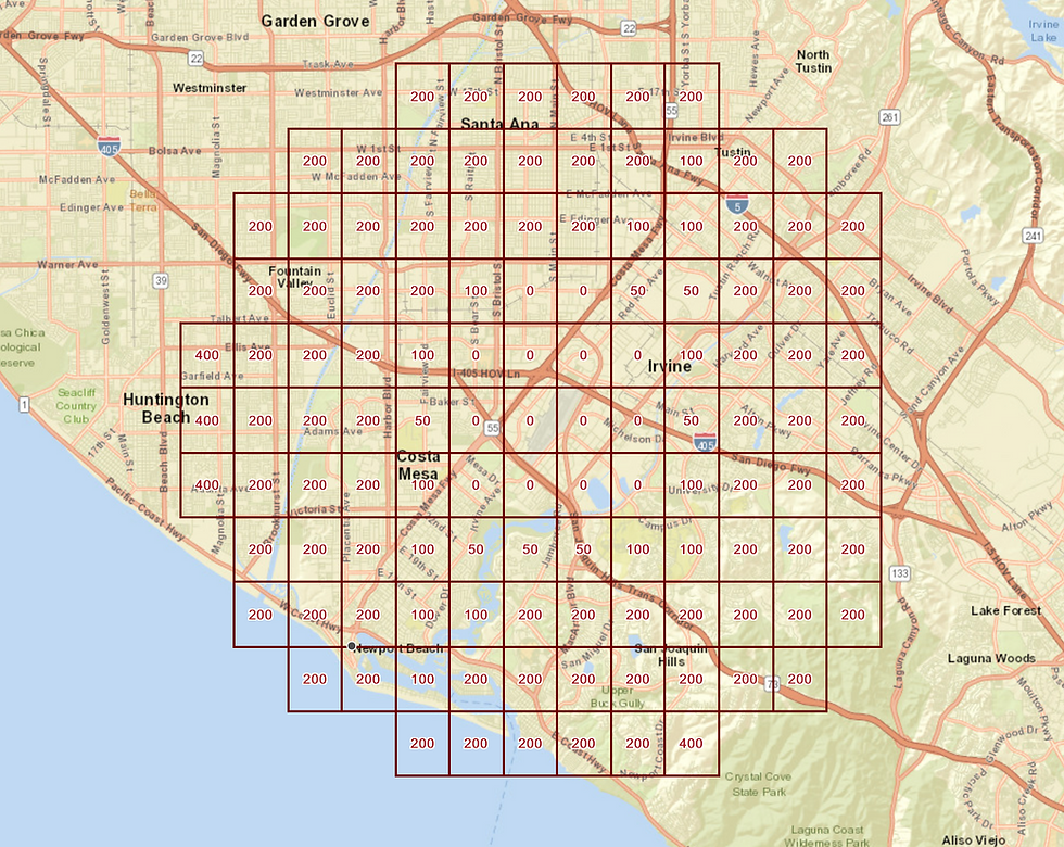
The FAA publishes a UAS Facility Map that divides controlled airspace into grid squares. Each grid carries a pre-approved ceiling: 400, 300, 200, 100, 50, or in some cases 0 feet. Request a flight at or below your grid's ceiling and approval is typically instant. Request above it, or in a 0-foot grid, and you're into a manual FAA authorization process that can take weeks.
This is the part that catches people out on tight deadlines. Grid ceilings vary block by block. A property on one side of a street may sit under a 200-foot ceiling while the one across from it allows 400. Some pockets near the approach paths are restricted to zero, meaning no automated authorization at all.
For a listing photographer, this is a practical matter, not a paperwork one. If the ceiling over your property is 100 feet, the sweeping shot that shows the whole lot and the water behind it may simply not be available, and you need to know that before the shoot rather than while standing in the driveway.
Part 107: the rule that separates commercial from recreational
If a flight is connected to a business in any way — marketing a listing, documenting a build, producing content for a brand — it is a commercial operation, and the pilot needs an FAA Part 107 Remote Pilot Certificate.
This catches more people than it should. An agent who owns a drone and flies their own listing is operating commercially. So is a contractor photographing their own jobsite for the company website. The test isn't whether money changed hands for the flight; it's whether the flight furthers a business purpose.
Alongside the certificate, a legal commercial flight requires:
Aircraft registration with the FAA
Remote ID compliance, either built into the aircraft or via an add-on broadcast module
Visual line of sight maintained throughout the flight
400 feet above ground level maximum, or lower where the airspace grid says so
No flight over non-participating people unless the aircraft meets the operational category rules for it
Airspace authorization where required, as above
Night flight is permitted under Part 107 with appropriate anti-collision lighting, which is how twilight exteriors get made legally.

Where you can launch matters as much as where you fly
Airspace is federal. The ground is not, and this is where most local confusion lives.
The FAA controls navigable airspace, so a neighbor generally can't claim you violated their property by flying above it. But takeoff and landing happen on someone's land, and whoever controls that land sets the rules there.
A few specifics that come up constantly in coastal Orange County:
California State Parks. State beaches and parks in the Orange Coast District restrict drone takeoff and landing. Crystal Cove State Park is the one that trips people up most, since so much of the coastline between Corona del Mar and Laguna falls inside it. You may be able to fly the airspace legally and still be prohibited from launching there.
City beaches and parks. City-managed beaches follow city rules, which differ from the state beaches next to them — and the boundary between the two is often invisible on the sand and very real on paper. Rules also differ city to city: Laguna Beach, Huntington Beach, Newport Beach and Dana Point each handle this their own way, and more than one has revisited its position over the years.
Private property. Launching from a client's driveway requires the owner's permission. That's straightforward on a listing shoot and worth confirming in writing on a commercial job.
The practical upshot: a professional operator scouts the launch point as carefully as the flight path, and sometimes launches from a legal spot to photograph a subject in a restricted one.
Drone rules Newport Beach | How to check before any specific flight
There is no single page that answers "can I fly here." Three authorities govern a given flight, and you check all three:
1. The airspace — FAA. Use B4UFLY or any approved LAANC provider app. Enter the exact location and it returns the grid ceiling and whether automated authorization is available. This is the only source that matters for airspace, and it's location-specific down to the block.
2. The launch point — landowner. If it's a state beach or park, contact California State Parks. If it's a city beach, park or street, contact that city. If it's private property, get the owner's permission. Whoever controls the ground controls takeoff and landing.
3. The city — directly. Municipal rules change, and third-party summaries online are frequently out of date or written for a different Newport Beach entirely. For a flight in Newport Beach, the City of Newport Beach is at (949) 644-3309 and the municipal code is published on newportbeachca.gov. Ten minutes on the phone beats a citation.
Anyone who tells you they know the rules for the whole county off the top of their head is telling you they haven't checked recently.
What this means if you're hiring, not flying
If you're an agent, broker, or developer, you don't need to learn any of this. You need to confirm that whoever you hire has:
A current Part 107 certificate — ask for the number, it's verifiable
Liability insurance covering drone operations, with your brokerage or firm named where appropriate
A habit of checking airspace before quoting a date, not after
The insurance point deserves emphasis. If an uncertified operator causes an injury or property damage while shooting your listing, the question of who carries liability becomes expensive quickly. A certificate number and a certificate of insurance take one email to request.
A note on timing
Authorization is the legal constraint. The marine layer is the practical one. Coastal Orange County mornings, particularly May through July, can sit under cloud until late morning, and a flight that's legally authorized at 8am may still be visually useless. Scheduling around that is its own subject, and it's the difference between a usable aerial and a gray one.
Newport Beach Media is an FAA Part 107 certified, fully insured aerial drone photographer based in Newport Beach, serving Corona del Mar, Laguna Beach, Dana Point, Huntington Beach, Costa Mesa, Irvine and all of coastal Orange County.
Call or text (949) 276-1972 for a quote.

Comments